bike2022
2022-06-23 to 30 Bike Trip Report
Map
Day 0
A person at the forest service office kindly offered that we could park our car for the next week at the forest service building at 2535 Riverside Drive, Clarkston, WA. We, Fritz Cathey and Brad Bell, drove from Seattle to Clarkston and stayed in a motel in Clarkston Washington Friday night.
Day 1
We parked the car in the Forest service parking lot (mile 0, feet 756). We rode the trail, on the river side of WA 129, to where the Asotin Creek road starts, We took the Asotin Creek road upstream to Cloverland Road. We took Cloverland, which goes up hill steeply with lots of switch backs and climbs out of the creek valley. There were lots of birds singing in the grass, the weather was beautiful, and there was hardly any traffic. Once the switch backs ended the grade eased up a bit and we continued climbing through farm land. At the intersection of Johnson and Cloverland the road surface changed from pavement to dirt (mile 21). the road transitioned from farm land to forest and eventually we reached the Cloverland Sno-Park (mile 27). Near there the road name changed to NF-43 We continued to the intersection with NF-4304 (mile 30, feet 5287). At this point a spectacular view of the Grand Ronde river valley and the Wallowa mountains opened up. We turned left (east) onto NF 4304 and camped just passed NF-040 on the left side of NF-4303 (mile 31).
Day 2
We headed east on NF 4303 intending to turn south and down to the Grand Ronde on NF 050. This was marked as a major road on the Gazetteer, but we missed the turn off. Instead we continued east on NF 4304, which is the major road but marked as minor on the Gazetteer. It is a beautiful road with great views to the south. At the exit from the national forest there was sign indicating the elevation (mile 38, feet 4800). At this point NF 4304 becomes West Mountain road. At the intersection of West Mountain and East Mountain roads both roads were major (mile 40, feet 4110). We realized we had missed the turn to NF 050 and back tracked for about an hour. At this point we decide that the road we had missed may in fact be minor or abandoned and so we turn around and head back to the interesting of East and West Mountain road. We took East Mountain Road to its intersection with Smyth road and then Smyth road to WA 129 (mile 44, feet 3886). We were worried that WA 129 would have a lot of traffic, but it had almost none and riding on it was very pleasant. We took it all the way down Rattle Snake grade and very rarely had to brake. We had been told there was a restaurant at the bottom but is was closed (mile 56, feet 1274). We headed upstream on the Grande Ronde Road and stopped for lunch at a public river access point a short way upstream. It was very hot continuing upstream on the Grand Ronde road to Troy. We stopped several times to cool off. I wet my hair and a rag that I placed on my shoulders. At Troy (mile 72, feet 1611) there was a restaurant where we stopped and had cold Gator Aid, I also had some chip and we filled our water bottles. We took the Troy road upstream along the Grand Ronde to about a mile before the Powwatka Bridge where we found a very nice site to camp along the river (mile 78, feet 1738).
Day 3
The next morning we rode across the bride to where the Troy road ends and followed the signs to Wallowa (Wallupa road on google but perhaps it is really the Wallowa road.) It was cool in the early morning and the road climbed steadily up a creek (with the same name) to the first switch back (mile 89, feet 3089). There the road left the creek and switched back two more times before arriving at the intersection with Promise road (mule 92, feet 3822). From there we took Promise road south toward Wallowa (not north toward Promise). Maxville was the next town on the map and we were hoping for a small store where we could buy a cold drink. We hoped to find Maxville at the top of the pass we were going over. When we got to the top, there was no town and we were well past Maxville, which we had not seen (mile 100, feet 4250). We stopped there to take pictures of the view of the Wallowa mountains. They seems much closer than at the end of Day 1. We had one of our typical lunches, peanut butter and jelly on flat bread or a tortilla. Then we rode down the hill to the intersection of Promise road OR 82. We turned left (south east) onto 82 and took it into Wallowa (mile 113, feed 2946). This road had actual traffic on it, not one car every 5 minutes or so as we had been experiencing. When we reached Wallowa, it was 94 degrees out and so we decided to take a break inside a restaurant. We both had Caesar salad and larges glasses of ice water. Looking at the map, and thinking about climbing in the heat, convinced us to take a room at the Mingo Motel (less than $100). It was about 3pm so I had plenty of time to change the tube in a tire that had been loosing air slowly. We did some organization of our gear and took showers and then had dinner at the same restaurant. That night we stayed up passed sunset (8:45pm) and watched episode one of series one of The Old Man.
Day 4
We got up about half an hour before sunrise (4:30am) the typical time for this trip. Had our breakfast in the room because the restaurants in town were not open yet. It was a typical breakfast, grape-nuts, with raisins, almonds, and or walnuts. We used powered milk (nido to be specific). Then packed our bags and headed up on Whiskey Creek road. The temperature was much more pleasant, I even had a windbreaker over a long sleeve shirt at the start. The windbreaker did not last as we climbed up hill. As it continues up hill, Whiskey Creek road is also called NF 3021. There is a point where it seems (according to google) that one can take a short cut and not have to go all the way up to Tope Creek. That did not work because the road does not seem to exists any more. Before crossing Tope Creek we turned right, which seems to continue on Whiskey Creek road. (If we had continued straight, we would have been on Tope Creek road.) For here the road was more dirt than gravel; i.e., not as major. There were lots of track crossing the road and we used one cell phones to keep us on the proper track (which is Whiskey Creek road on google). About 2 miles before the intersection with OR 3 the road name changes from Whiskey Creek to an unnamed road (on google maps). We took the unarmed road to OR 3 (mile 133, feet 4706). There was very little traffic on OR 3 which we took south, and down hill, to NF 46 (mile 135, feet 4318). We turned east and followed NF 46 which started up hill, then south east and down into what looks like a creek crossing (but there was no creek), then north and up hill to a pass, then down hill and along Elk Creek to NF 100 (mile 147, feet 3440). From there following we followed Elk Creek first on NF 100 and then on NF 4600. Then at Crow Creek road we turned left and followed Crow Creek down hill. Just after Crow Creek road crossed Chesnimnus Creek, followed Chesnimnus Creek up hill (turned right) (mile 150, feet 3275). The road up Chesnimnus Creek at first is called Crow Creek road and then is called Chesnimnus Creek road. At some point is also called NF 4625. We followed Chesnimnus Creek road / NF 4625 up hill to Vigne Campground, which is on a side road that goes down to the river. Unfortunately, this campground has been abandoned and is over run by cows. We managed to find a good place to cam near the and away from the main camping area (mile 161, feet 3810).
Day 5
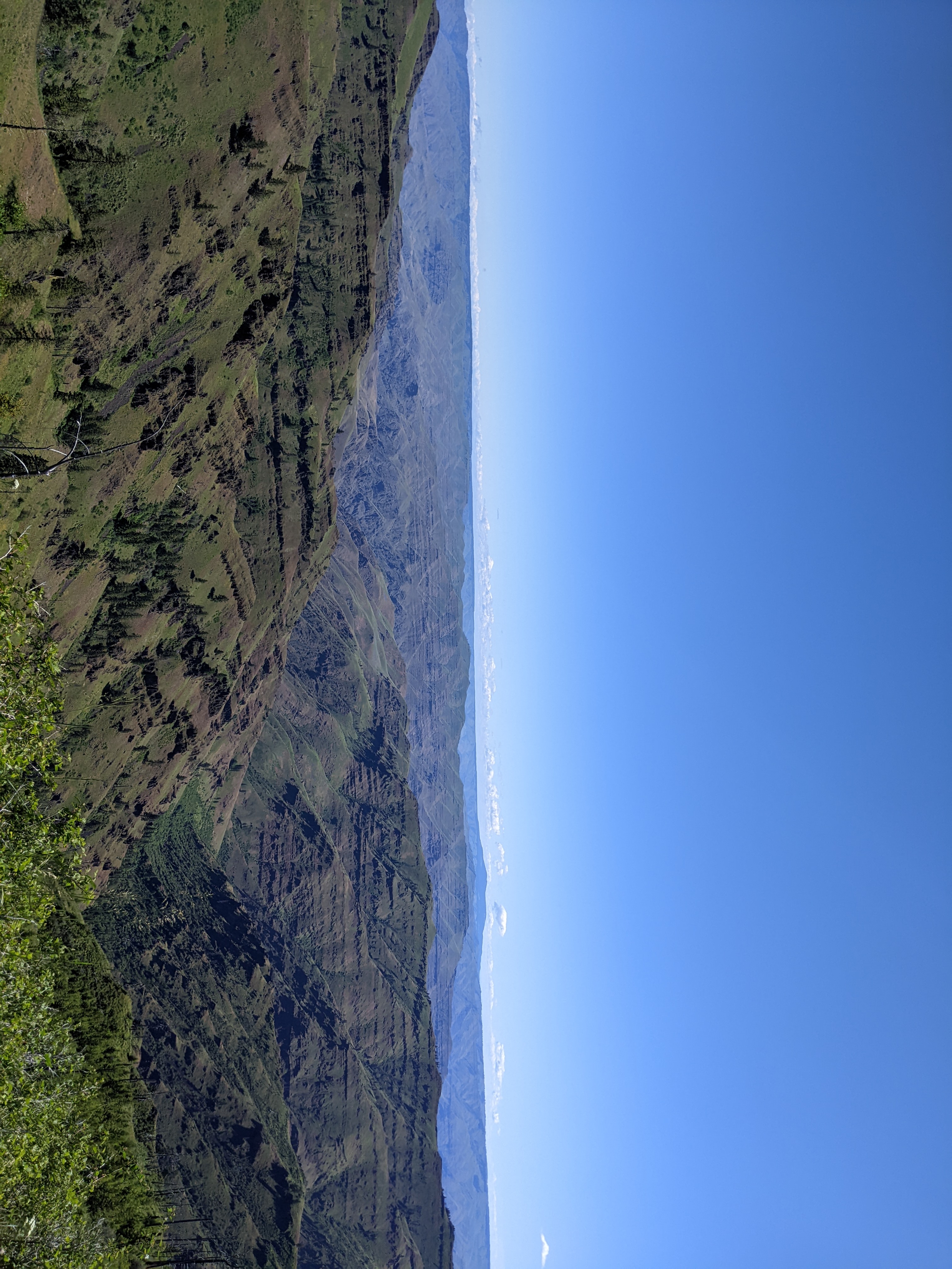
We continued up hill on NF 4625 to NF 46 (mile 170.4, feet 5362). About 1.6 miles before the intersection with NF 46 google maps had NF 4625 going to the right, and Chesnimnus Creek road going left. The road to the right at this point was abandoned so we took the left road which was the true NF 4625. (The sign at the intersection with NF 46 indicated we were on 4625). We turned right at this intersection and rode to NF 4680 / Cold Springs road which we took to the left (north). There was a sign before the intersection saying that this road would get us to the Grande Ronde. There was a sign after the intersection saying that this road was rough and not intended for passenger vehicles. After a few miles on this road the scenery changed from forest to high meadow with were fantastic views of Hells Canyon to the east; see Hells canyon picture . The road continued on very pleasantly for until we reached the six mile point. At this point the road became very rocky and headed down hill (mile 176, feet 5473). Shortly after starting down hill google maps has Cold Springs Road going the left and NF 4680 going to the right. The road to the left was very faint (but did appear to still be used). We took the road to the right. As the road descends the road name changes to Horse Creek road and then Joseph Creek road. The rough rocky road continued down the hill until we crossed from Oregon into Asotin county Washington. Once we were in Asotin county it became a well maintained gravel road. At the lower end of Chief Joseph State Wildlife Recreation area there is a road that crosses to the other side of Joseph Creek and goes back up stream. We took this road for a short distance and found a good place to camp (mile 194, feet 970). There was one problem though, it was in a field of cheat grass. We already had cheat grass stuck in our socks from earlier exploration looking for a place to camp. (It was so much and hard to remove, that I just though the socks out when I go home.) Dinner that night was typical, dried chicken soup mix, plus salmon (from a foil packet), plus extra noodles, plus extra salt, plus lots of pepper. (Sometimes we would mix in tuna or salami instead of salmon.)
Day 6
We continued down Joseph Creek road to where it crosses the Grande Ronde river and becomes the Snake River road. From there, is a short distance to the confluence with the Snake At this point the road is paved and it is very easy going down stream along the snake river. There are lots of sandy beaches along this stretch. We also saw lots of blue herons and people fishing along the river. Not far from the town of Asotin there was a large colony of sparrows on the cliff to the left. There was not much traffic until we reached the town of Asotin. In Asotin we bought some drinks and drank them in the shade in a park by the river. There is a bike trail, along the river and away from the traffic, that we were able to take after we passed Asotin Creek heading north. We took this the rest of the way back to our starting point (mile 225, feet 758).
Pictures
Hells Canyon